
Seafarers Sailing Club is located on the northern edge of the Solent. The prevailing wind is from the southwest ie the direction of Cowes. The warmth on summer days can lead to a robust sea breeze from this direction.
Actual Weather
Seafarers SC
The Club is to install a weather station. The output will be available from the “Weather Station” link in the SEE ALSO menu to the right. Currently the wind, temperature, pressure and rainfall shown are simulated, not measured.
Bramblemet
A weather station has been set up on a post on the Brambles Bank which is about 2 miles from Seafarers in the direction of the prevailing wind. The website at Bramblemet holds the weather information gathered from this weather station.
Hill Head SC
A mile or so to the northwest of Seafarers so the weather conditions are very similar and they have their own weather station. Their live weather feed is available from the Club’s website.
Stokes Bay SC
Three miles southeast of Seafarers; has its own weather station.
Webcams
Seafarers SC
The Club is to install a webcam. The output will be available from the SEE ALSO menu to the right.
Hill Head SC
Hill Head Sailing Club has webcams mounted on its clubhouse adjacent Titchfield Haven approximately 0.8 mile northwest of Seafarers providing a useful view of the Solent.
Forecast Weather
Hill Head (Beach)
The UK Met Office provides a very useful forecast for the Seafarers’ area (see Hill Head (Beach) in SEE ALSO menu.
Lee on Solent Weather
This is another useful local forecast site.
Tides
Tide Clock
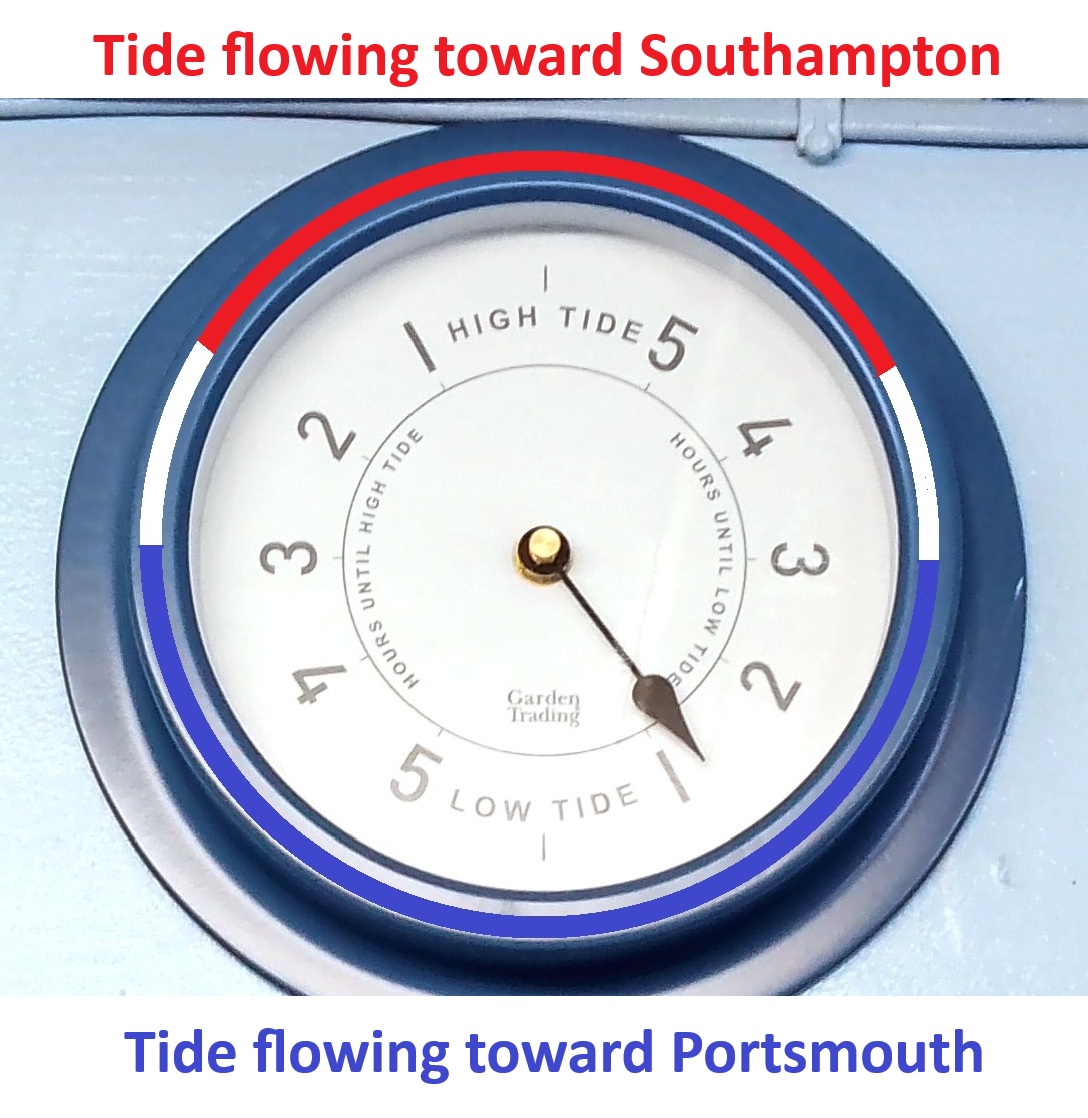
A tide clock has been installed in the wetroom above the blackboard. It shows the current state of the tide at the Club in terms of hours before high water and hours before low water.
At our location, the tide flows toward Southampton from 2 hours before high water until 2 hours after high water. It flows toward Portsmouth from 3 hours after one high water until 3 hours before the next high water. These periods are marked in team-appropriate colours on the image of the tide clock below.
Easy Tide
Maintained with data from the UK Hydrographic Office, this site gives tidal information for all major ports; the link is set for the Portsmouth tidal information at Portsmouth. Remember to set “Daylight Saving” to 1 hour when clocks are set to BST.
Water Temperature
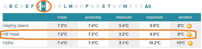
The website Sea Temperature Info provides information on current and historical data on temperatures of the oceans, seas, lakes and rivers of the most famous holiday resorts, beaches and coastal cities around the world. To see the water temperature at Hill Head, go to the Hampshire page of the website (Water Temp in SEE ALSO), then click on “H“:
Water Quality
Water contamination caused by the discharge of untreated sewage has been in the headlines recently. Water quality can also be reduced by heavy rainfall causing the input of pollution from sources such as roads and agricultural run-off.
Safer Seas Service is an award-winning, free app promoted by “Surfers Against Sewage” (SAS), an environmental charity dedicated to the protection of oceans, waves, beaches and wildlife. This pioneering service alerts water users when sewer overflows discharge untreated human sewage into the sea and when water quality is temporarily reduced due to heavy rainfall and pollution incidents.
For more details and to download the app (Android and iOS versions are available), go to the SAS’s Safer Seas Service webpage – SAS in SEE ALSO menu..